


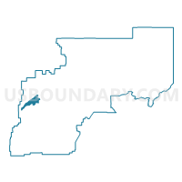
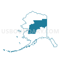
Koyukuk Precinct, Yukon-Koyukuk Census Area, Alaska
About
Outline

Summary
| Unique Area Identifier | 523570 |
| Name | Koyukuk Precinct |
| County | Yukon-Koyukuk Census Area |
| State | Alaska |
| Area (square miles) | 930.16 |
| Land Area (square miles) | 890.58 |
| Water Area (square miles) | 39.57 |
| % of Land Area | 95.75 |
| % of Water Area | 4.25 |
| Latitude of the Internal Point | 64.88511980 |
| Longtitude of the Internal Point | -158.49065390 |
Maps

Graphs
Select a template below for downloading or customizing gragh for Koyukuk Precinct, Yukon-Koyukuk Census Area, Alaska


Neighbors
Neighoring Voting District (by Name) Neighboring Voting District on the Map
- Galena Precinct, Yukon-Koyukuk Census Area, AK
- Huslia Precinct, Yukon-Koyukuk Census Area, AK
- Kaltag Precinct, Yukon-Koyukuk Census Area, AK
- Nulato Precinct, Yukon-Koyukuk Census Area, AK